")
")
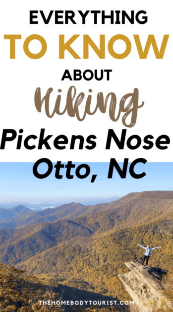
Hiking Pickens Nose Trail
While roadtripping through the American Southeast, I did a quick google search for “The best hikes in North Carolina”. I saw a google image of Pickens Nose Trail and knew I HAD to see it for myself.
With a bit more research I read that the road was rough, but I didn’t find much more. My expectations were low, but ultimately I was BLOWN AWAY. I don’t like to pick favorites….buttttt Pickens Nose Trail is up there! 🙂
This site contains affiliate links to products. I only show products I have tried and love. I may receive a small commission for purchases made through these links at no extra cost to you. Thank you for your support!
Table of Contents
Where is Pickens Nose Trail Located?
Pickens Nose trailhead is located within the Nantahala Forest in Otto, North Carolina. The closest big cities are:
- Asheville, NC: 87.9 miles
- Atlanta, GA: 129 miles
- Chattanooga, TN: 139 miles
- Nashville, TN: 269 miles
What is the best time to visit?
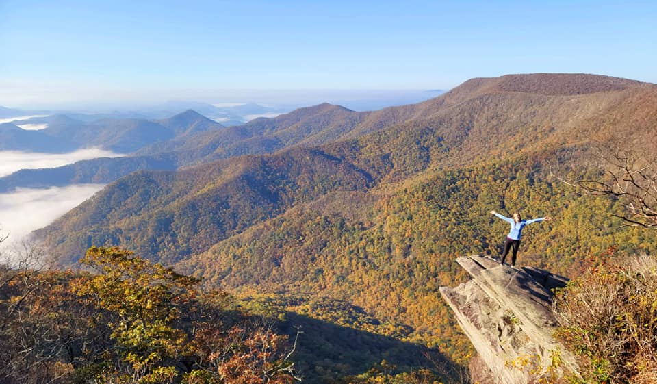
I may be completely biased in this response, but during peak fall colors was AMAZING (I mean look at that picture!). We visited during the third week in October.
Due to the treacherous road (detailed below), the road closes in the winter. I also would not advise the drive after or during heavy rain.
IMPORTANT: The road is completely closed from January 1st to the end of winter. Check here for seasonal updates.
Hint: Due to the short hike and magnificent views, it would make for the BEST spot to watch the sunrise or sunset.
How do you get to the Trailhead?
As stated previously, the road to the trailhead is ROUGH. When I first read the reviews, I sort of dismissed it. I mean…I grew up on a dirt road so I figured it couldn’t be THAT bad.
WELL it was pretty bad.
It consisted of a one-lane dirt road with MANY hairpin turns, big rocks, and holes. We did it in my Corolla, so it is possible, but just be sure to go slow.
Is there an alternate route?
You can reach Pickens Nose trailhead from the East and the West. They are both dirt roads, but the east is worst. We drove in on the east way but decided to go out on the west way (Standing Indian Campground route) to save my car a bit. It is a bit longer, but worth it in my opinion.
Hint: On the way out to Standing Indian campground, we passed several other trailheads. If you have time, they would be the perfect pit stops!
Where to park?
After you trek up the mountain, you will come across a small (about 6 cars) pull-out area at the trailhead. We arrived around 10 am and there was only one other car!
Tip: Be sure to put the trailhead address (“Pickens Nose Trail”) into your GPS BEFORE leaving as there is not service almost the entire way.
Pickens Nose Hike Details
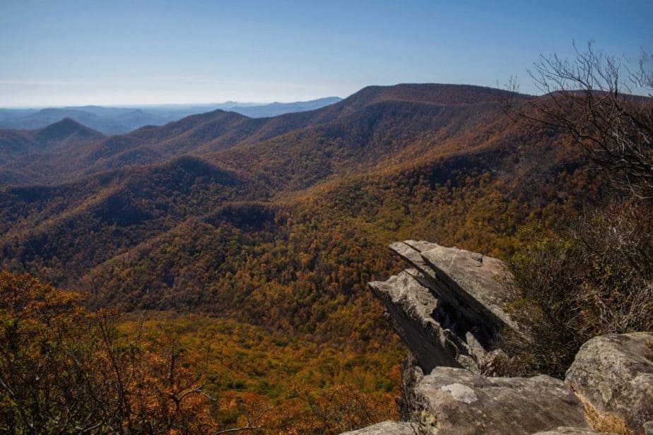
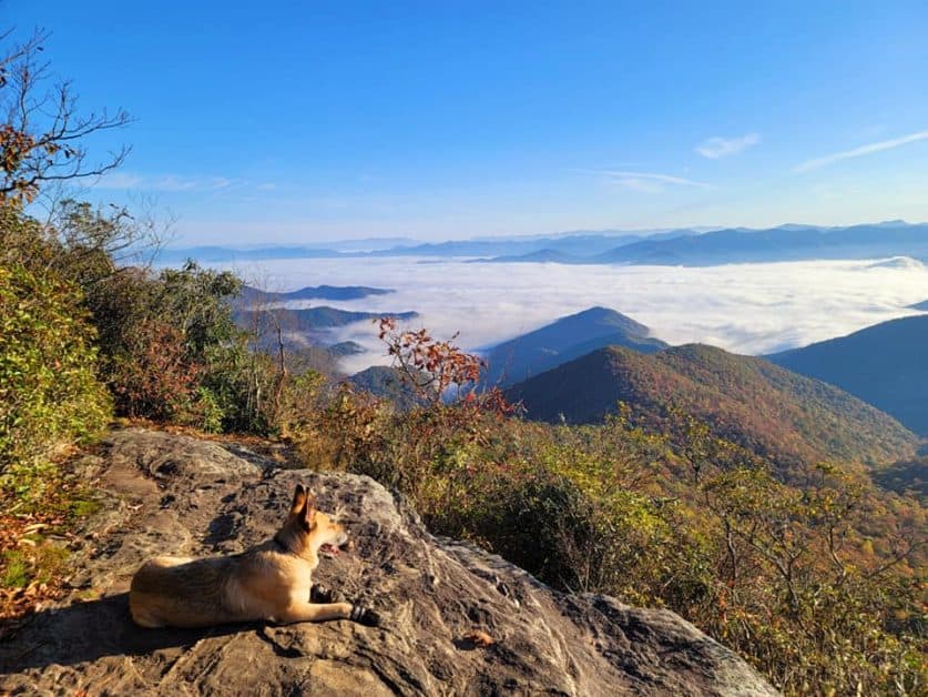
The hike itself is pretty easy and straight forward. Once you make it up the initial incline be sure to check out all the “side paths” you can find as they all lead to amazing views (Check both sides of the trail). The two pictures above were off of these side paths!
- Address: Pickens Nose Trailhead-Ball Creek Road, Otto, NC
- Length: 1.4 miles (out and back)
- Elevation Gain: 295 ft
- Dogs Allowed? Yes!
Day Hiking Essentials:
- Day pack with water bladder– This one is my FAVORITE as it is super affordable, comfy, and big enough to hold water and allll the snacks.
- Hiking boots– I usually wear my keen sandals, but on chillier hikes, I have recently started wearing these keen boots. I love them just as much!
- Collapsible doggy dishes– Make sure to give your pup plenty of water as there are not any water sources on this hike!
- Travel first-aid kit– Better safe than sorry! AND it can attach right to your backpack
- Doggy boots– If your pup has sensitive paws like mine (yes I know…major drama king), but they are helpful in preventing cuts from the rocks.
- Headlamp– In case you are hoping to catch the sunset/sunrise!
Other things to do near Pickens Nose Trail
- Stroll the streets of the CUTEST German village in Helen, GA (51 miles)
- Walkthrough a creepy tunnel at Issaqueena state park (43 miles)
- Explore BEHIND a waterfall at Dry Falls (30-40 miles depending on which way you leave the trail)
- Marvel at the HIGHEST waterfall (east of the Rockies) at Whitewater Falls (50+ miles)
- Road trip to Chattanooga (with your pup of course!)
Where to stay?
There are many cute and cozy cabins located in the Nantahala Forest. If you read my Southeast Road Trip Itinerary, you saw that we stayed near Helen (at this dog-friendly cabin) and completed a day trip to Pickens Nose Trail.
Here are some other options that are near the hike!
Let’s be FRIENDS! Follow me on Instagram or join our private Facebook Group for alllll things USA road trips and dog-friendly travel ideas!
")

Comments Off on Hiking Pickens Nose Trail